Lighthouse collection - almost 200 photo's of Dutch lighthouses
This site brings together my lifelong passions — collecting stamps and more.
|
For some must watch, while some must sleep, so runs the world away. |
Just a quick overview. See below for the index.
Ameland: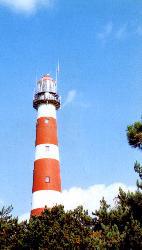
|
Location: Build: Visibility Material: Shape: Levels: Height: |
53-27,0N 5-37,6E 1880 - 1881 35 km cast iron round 15 55,3 meter |
Terschelling - "Brandaris":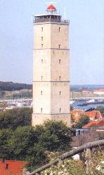
|
Location: Build: Visibility Material: Shape: Levels: Height: |
53-21,7N 5-12,9E 1593 - 1594 35 km yellow brick square 5 55,5 meter |
Den Oever:
|
Location: Build: Visibility Material: Shape: Levels: Height: |
52-56,2N 5-02,6E 1884 15 km cast iron hexagon 4 15,5 meter |
Egmond aan Zee:
|
Location: Build: Visibility Material: Shape: Levels: Height: |
52-37,2N 4-37,4E 1833 - 1834 31 km brick round 7 34 meter |
Eierland: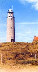
|
Location: Build: Visibility Material: Shape: Levels: Height: |
53-11,0N 4-51,4E 1864 - 1864 36 km brick round 7 54 meter |
Hoorn: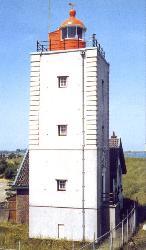
|
Location: Build: Visibility Material: Shape: Levels: Height: |
52-44,6N 5-17,0E 1834 19 km brick square 4 17 meter |
IJmuiden: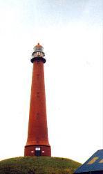
|
Location: Build: Visibility Material: Shape: Levels: Height: |
52-27,7N 4-35,0E 1878 36 km cast iron round 11 53 meter |
Maasvlakte: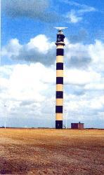
|
Location: Build: Visibility Material: Shape: Levels: Height: |
51-58,3N 4-00,9E 1974 38 km reinforced concrete octagon 26 67,5 meter |
Nieuwe Sluis: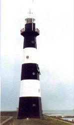
|
Location: Build: Visibility Material: Shape: Levels: Height: |
51-24,5N 3-31,4E 1867 26 km cast iron octagon 5 28,4 meter |
Noordwijk: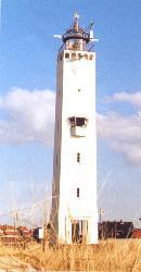
|
Location: Build: Visibility Material: Shape: Levels: Height: |
52-15,0N 4-26,1E 1921- 1922 29 km brick square 6 33 meter |
Scheveningen: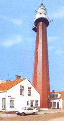
|
Location: Build: Visibility Material: Shape: Levels: Height: |
52-06,3N 4-16,2E 1875 36 km cast iron 12 sides 10 49 meter |
Urk: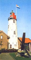
|
Location: Build: Visibility Material: Shape: Levels: Height: |
52-39,7N 5-35,6E 1844 - 1845 33 km brick round 4 27 meter |
Vlieland: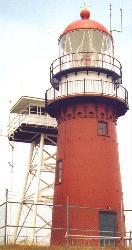
|
Location: Build: Visibility Material: Shape: Levels: Height: |
53-17,8N 5-03,6E 1864 37 km brick/cast iron round 3 54 meter |
INDEX of all Dutch lighthouses
Click to see explore more photo's
- Ameland
- Borkum
- Breskens
- De Ven
- Den Helder - De lange Jaap
- Delfzijl
- Den Oever
- Egmond aan Zee
- Eierland
- Goeree
- Haamstede
- Harlingen
- Hellevoetsluis
- Hoek van Holland
- Hoek van 't IJ
- Hoorn
- Katwijk
- Kraggenburg
- Lemmer
- Marken
- Nieuwesluis
- Noordwijk
- Ouddorp
- Scheveningen
- Schiermonnikoog
- Stavoren
- Strijensas
- Terschelling
- Texel
- Urk
- Vlieland
- Vlissingen
- West Kapelle
- West Kapelle Noord
- Westschouwen
- IJmuiden